Humminbird adds new regions to Lake Master coverage
EUFAULA, AL (January 6, 2015) – Humminbird is now ready to bring the LakeMaster experience to more anglers across the U.S. than ever before. Our survey team has expanded the High Definition map coverage into the MidAtlantic and NorthEast regions with new, Version 1 Editions for anglers.
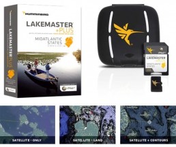
In addition to these two regions, we’ve added a new PLUS version of these products as well. The PLUS series allows for aerial image overlay on High Definition waters in addition to all of the LakeMaster features. Now you have the ability to use quality aerial photography to view the entry and exits of creek channels, see how far a reef or weed line extends, and pick out shallow water rock piles, steep drop-offs or other features of the lake you’ve been missing from traditional maps.

- Contours for over 100 total lakes, rivers and reservoirs in DE, MD, NC, SC, VA, & WV
- 42 High Definition water bodies, including several sections of the Ohio River
- Updated coastline for the entire region
- i-Pilot® Link™ Compatible
Includes these highly requested water bodies in stunning High Definition: Strom Thurmond, GA/SC, Lake Murray, SC, Smith Mountain, VA, Kerr/Buggs, NC/VAGaston, NC, Wylie, NC, Norman, NC, and Shearon Harris, NC. Also, contours for Chesapeake Bay, MD and Delaware Bay, DE.
Visit MidAtlantic States Edition for more information on product features, images, complete lake list, lake elevations, GPS compatibility and more.
MidAtlantic States PLUS Edition
- Contours for over 100 total lakes, rivers and reservoirs in DE, MD, NC, SC, VA, & WV
- 42 High Definition water bodies, including several sections of the Ohio Rivers
- Updated coastline for the entire region
- i-Pilot® Link™ Compatible
- PLUS allows for 3 layers of aerial image overlay on High Definition waters: Satellite Only, Satellite + Land, Satellite + Contours
Includes these highly requested water bodies in stunning High Definition: Strom Thurmond, GA/SC, Lake Murray, SC, Smith Mountain, VA, Kerr/Buggs, NC/VA, Gaston, NC, Wylie, NC, Norman, NC and Shearon Harris, NC. Also, contours for Chesapeake Bay, MD and Delaware Bay, DE.
Visit MidAtlantic States PLUS Edition for information on product features, images, complete lake list, lake elevations, GPS compatibility and more.

- Contours for over 1,500 total lakes, rivers and reservoirs in CT, MA, ME, NH, NJ, NY, PA, RI, & VT
- 115 High Definition water bodies
- Updated coastline for the entire region
- i-Pilot® Link™ Compatible
Includes these highly requested water bodies in stunning High Definition: Zoar, CT, Lake, Lillinonah, CT, Winnepesaukee, NH, Winnesquam, NH, Webster, MA, Androscoggin, ME, China, ME, Cobboseecontee, ME, Hopatcong, NJ, Conesus, NY, Johnsons Pond, RI, Wallenpaupack, PA, Dunmore Lake, VT and contours for all of Lake Ontario.
Visit NorthEast States Edition for information on product features, images, complete lake list, GPS compatibility and more.
- Contours for over 1500 total lakes, rivers and reservoirs in CT, MA, ME, NH, NJ, NY, PA, RI, & VT
- 115 High Definition water bodies
- Updated coastline for the entire region
- i-Pilot® Link™ Compatible
- PLUS allows for 3 layers of aerial image overlay on High Definition waters: Satellite Only, Satellite + Land, Satellite + Contours
Includes these highly requested water bodies in stunning High Definition: Zoar, CTLake Lillinonah, CT, Winnepesaukee, NH, Winnesquam, NH, Webster, MA, Androscoggin, ME, China, ME, Cobboseecontee, ME, Hopatcong, NJ, Conesus, NY, Johnsons Pond, RIWallenpaupack, PA
Dunmore Lake, VT and contours for all of Lake Ontario.
Visit NorthEast States PLUS Edition for information on product features, images, complete lake list, GPS compatibility and more.

For more information visit humminbird.com, contact Humminbird, 678 Humminbird Lane, Eufaula, AL 36027, or call 800-633-1468.